Borehole Low-Frequency Electrical Prospecting.
V.I. Veksler, S.O. Perekalin, A.R. Slonimsky
Gela, 12b Novotorzhskaya St., Moscow, Russia
Скважинная низкочастотная электроразведка.
Векслер В.И., Перекалин С.О., Слонимский А.Р.
Гела, Россия, 170000 г.Тверь, Новоторжская ул. 12б
As distinct from a well logging an investigation object of a borehole electrical prospecting is a visinity of a borehole at a distance far exceeded the borehole diameter.
In this case a borehole is used only as a possibility to set the sensitive tool and to measure the electromagnetic field at the depth. The technologies based on the measuring of quasi-stationary electromagnetic fields are called borehole low-frequency electrical prospecting. This area exists in geophysics for thirty years. The development and application of the borehole low-frequency electrical prospecting was due for a long time to a well drilling in ore fields. As the interests to an orebody geophysics compared to an oilfield one continue to decrease we, one of the first inventors of the borehole low-frequency electrical prospecting, expect that it will be useful to review some possibilities of this technologies for solving geological and technical problems in oil fields.
All methods of the borehole low-frequency electrical prospecting are joined together with the requirement of possibility of measuring of the whole A.C. magnetic field vector or its three Cartesian components. This requirement involving some evident difficulties is of the principal importance. The magnetic field measuring contrastly to the electric field one permit to exclude the obstructive influence of the inhomogenities in the observation point. The measuring of three A.C. magnetic vector components in comparison with the easily realisable measuring of only one component directed along a borehole axis gives important information of the explored object location. In comparison with the surface measurements the borehole vector measurements compensate the information lack associated with the availability of only one measuring line - borehole, while in the field geophysics the areal measurements are available.
The borehole low-frequency electromagnetic technologies are distinguished by the character of the electric current responsible for the magnetic field, which is measured. Choosing of the technology depends on the distribution of the conductivity in the exploring area and of the investigation aim.
In the case when the conductivity distribution could be introduced by the local electrical conductors situated in the practically insulated media and the investigation aim is the study of the conductors shape, location and electrical parameters the electric currents, caused the magnetic field magnitude sufficient for measurements, may be produced by the electromagnetic induction. The excition source of the inducting A.C. magnetic field could be different coils or loops supplied with electric current by the generator. The technologies based on this principle are called inductive low-frequency electrical prospecting methods.
In the case of low resistivity media the excitation array may be introduced by the electrode system via which the electric current is injected in the media. The conductivity inhomogenities affect the electric current distribution that cause the anomalous magnetic field, which contain the important information about the inhomogeneties for the goal to be sought. This group of technologies is called "magnetic fields of current" methods

Let us consider some borehole low-frequency electromagnetic methods, which are used or may be used in oilfield geophysics.
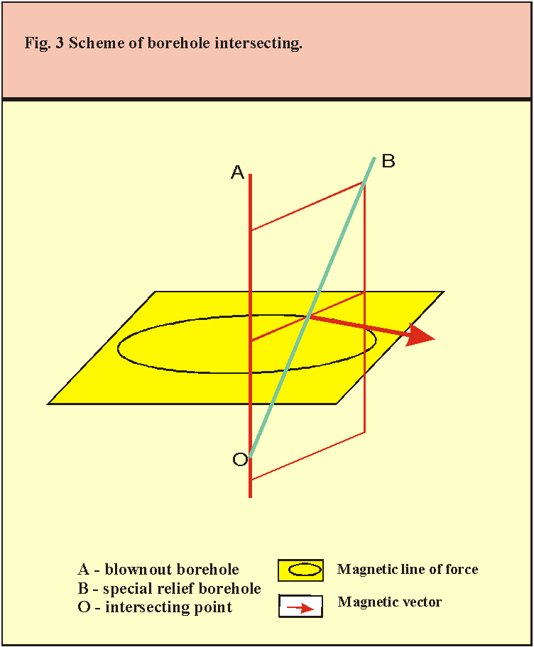
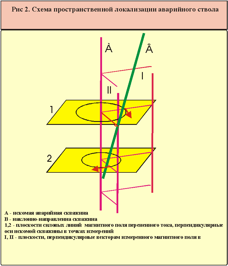
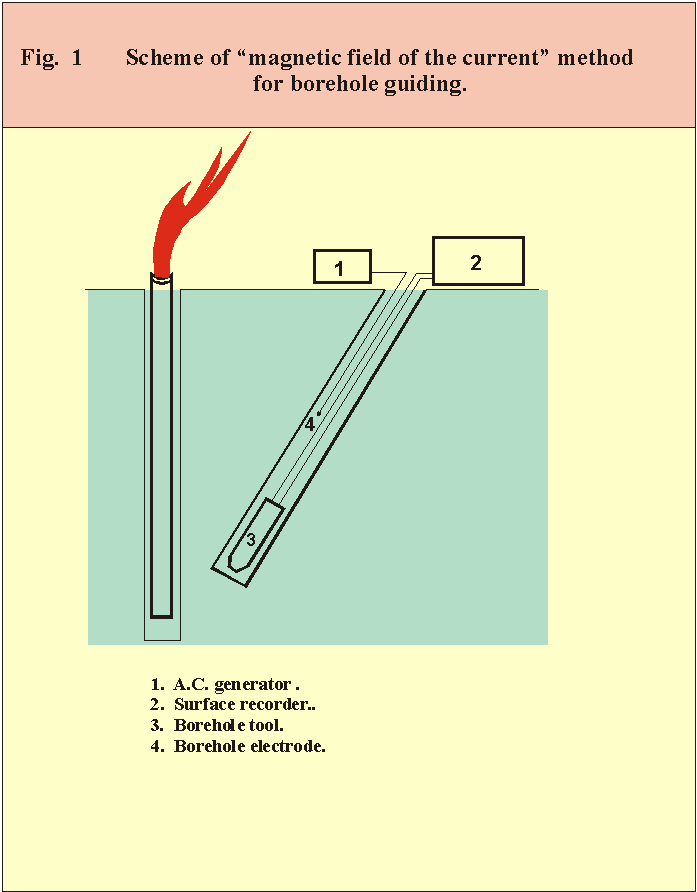
If the tubing or casing are situated in the blownout borehole the problem could be formulated as the localisation of the linear electrical conductor in the space round the special relief borehole. The exciting array consists of two electrodes one of which is situated at some distance above the sensitive unit and the other on the surface of the earth (Fig.1). The magnetic field of the current concentrated in the tubing of the blownout borehole is orthogonal to the plane that is complainer with the borehole axis. The line of intersecting of such planes coincides with the axis of the blownout borehole (Fig.2). Thus the blownout borehole location could be find by means of the magnetic field measuring. The reliability of the method is based on only assumption that the magnetic field of the current flew along the practically linear conductor is 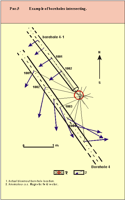 symmetrical about its axis.

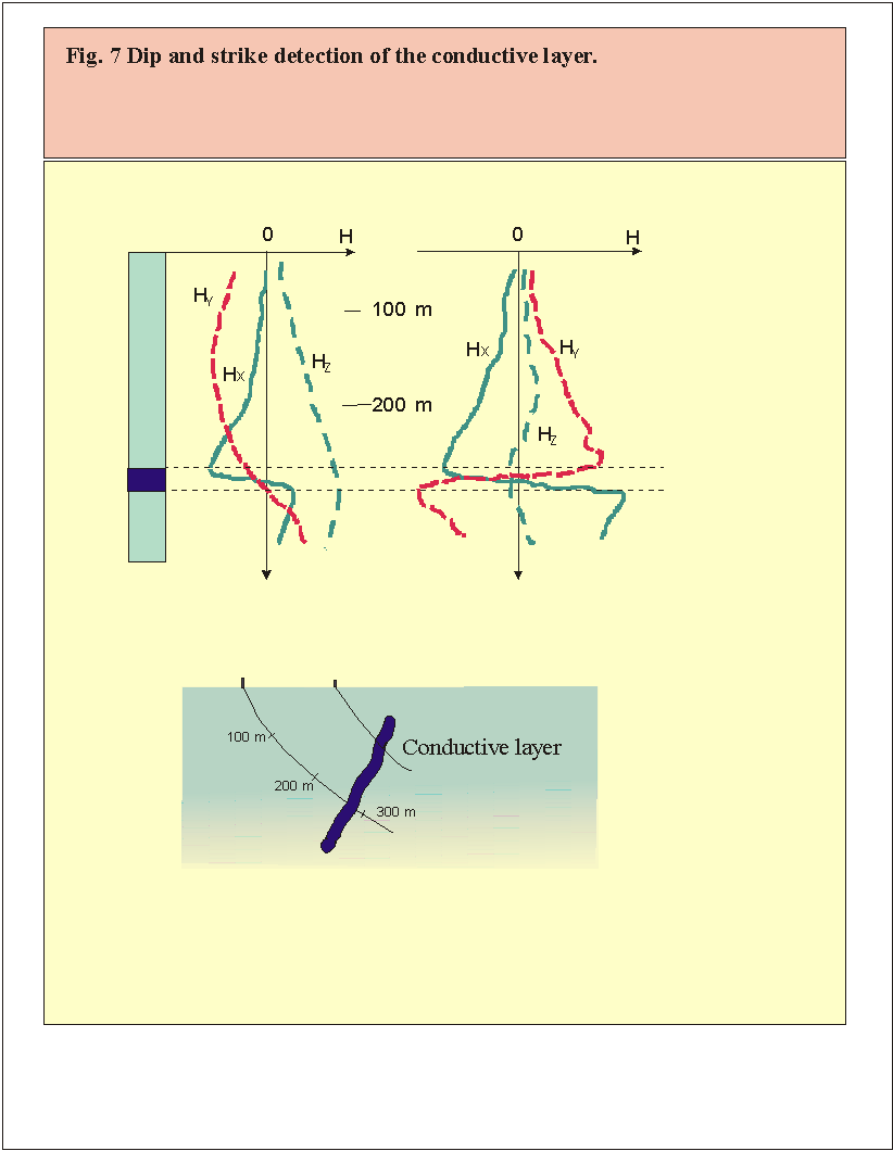
The example of searching the blownout location at the depth is introduced on Fig.4. The boreholes are shown as a projection on the plane that is orthogonal to a blownout borehole. The stage of the borehole intersecting is shown on the Fig.5.
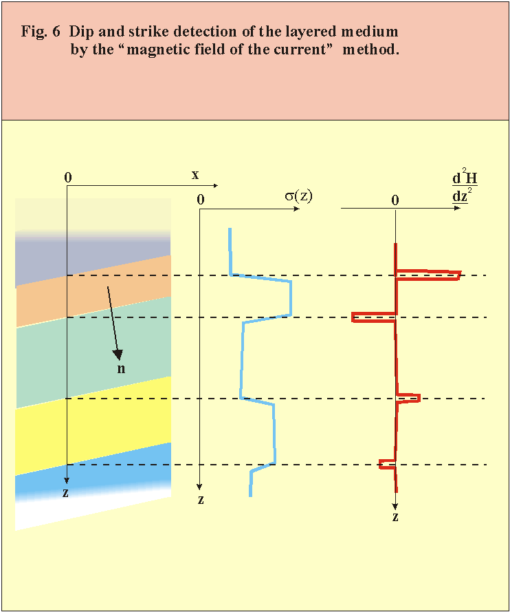
The "magnetic field of the current" method permits also to detect the dip and strike of the layered medium in the vicinity of the borehole. This information is taking in account while oil field modelling [2].Let the borehole to intersect the layered medium in which the conductivity variation is occurred in the direction n. The function s (z) describes the conductivity variation along borehole axis z (Fig.6). If the medium is excited by the remote electric current source and its primary current density vector is essentially not in parallel with n, it would appear the anomalous current density component i , which is complainer with the layers and is in proportion to s (z). The magnetic field H, connected with this component, is defined as rotH=i, that in this case is equal to equation dH/dn=i , where derivative is taken with respect to distance n, measured along n. dH/dn is in proportional with dH/dz. Thus the magnetic field H could be extracted as a part of the measured magnetic field which is correlated with the function s (z) known from the well logging data. Practically the extracting of this field is facilitated by stepwise character of s (z) that leads to appearing of extremums in magnetic field component logs.
The vector product of two derivative of magnetic field vectors, obtained in one observation point at two different electric current sources, coincides with the orthogonal to the layers direction n, that is to be found.
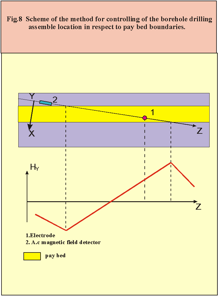
The method can be used to control the bottom borehole assemble in respect to the pay bed boundaries while horizontal drilling [3]. If the conductivity of pay bed is low then the adjacent formation the magnetic field of the electrode situated near the bit can give a reliable information about its location in respect of the layer boundaries. Changing of direction of the horizontal and orthogonal to a borehole axis magnetic component is the indicator of intersecting of the middle line of the layer by the borehole. The scheme of the array for control the borehole drilling assemble location in respect to the pay bed boundaries is shown in the Fig.8.
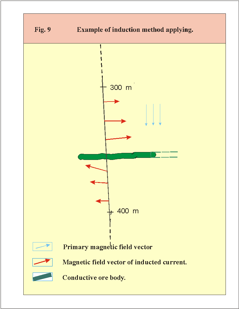 The borehole low-frequency inductive methods [4] could be also applied in the oil geophysics for detection of the saline water reservoir in the vicinity of boreholes drilled in the salt formation. Inductive magnetic field measurements can give the information about the shape and location of the reservoir in the vicinity of the borehole including the case, when the salinity water reservoir is situated below the borehole bottom. In the Fig.9 it is shown the results of magnetic field vector measurements in the borehole crossed the ore layer situated in the low conductivity formation. It is obvious that such a layer could be detected at the distance about several hundred meters between a borehole bottom and a layer. It is also possible to obtain the information about location of the nearest edge of the layer.

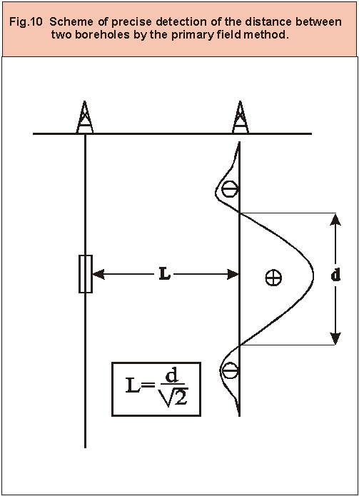 The primary field method was developed firstly to obtain the precise distance between the charge and measuring boreholes during Soviet-American experiment aimed on magnitude control of nuclear explosions [5]. The scheme of the method is shown in the Fig10. The vertical magnetic oscillator was set in one of the boreholes at the required depth. In another borehole there was performed the measurements of the axial component of magnetic field, which character is greatly depends of the distance between the boreholes. The accuracy of the distance detection was low then 1%.
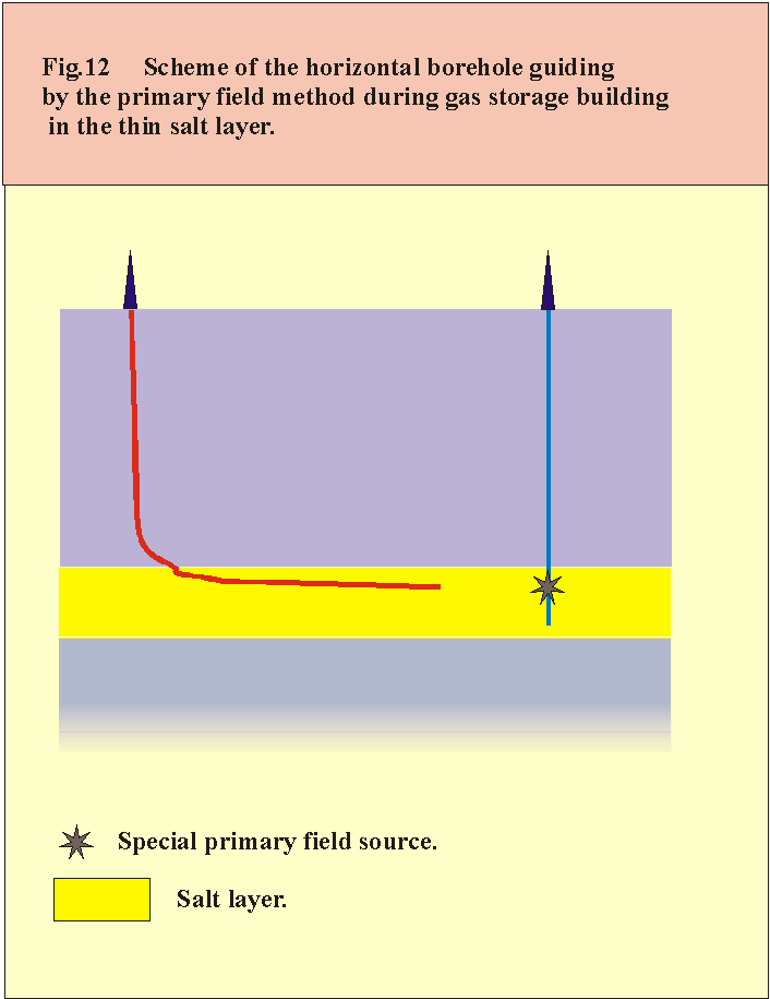
The primary field method is very important while building of the gas storage in the respectively thin salt layers. The solving of the problem is connected with horizontal drilling of a special borehole within the salt layer to obtain the direct contact with the vertical borehole of another well drilled before (Fig.12). We create a project of such horizontal borehole guiding by using a special source of the primary field.
Thus, the Gela firm is engaged in the developing and applying of the technologies and tools for solving following problems:
- directional well drilling with the aim of searching, locating and intersecting of the metallic string of pipes situated in the other well;
- drilling of the branch borehole round the sticked section of tubing in order to enter the main hole under the shoe of the sticked section;
- the precise detection (with the accuracy not more that 1%) of distance between two noncased boreholes available for logging operations;
- the control of the drilling tool location within the borders of the pay bed during the horizontal drilling;
- preventing from a casing damaging of the previously drilled boreholes during a multiple drilling;
-Investigating of the shape and location of a salinity water reservoirs in the vicinity of a borehole;
- horizontal borehole guiding on the vertical borehole target within a salt layer during a gas storage construction.
Bibliography.
The Authors

Vladimir I. Vexler is Director of Gela Ltd. Previously, he was Head of Laboratory of the electromagnetic methods in the Central Research Institute of Geological Prospecting (TsNIGRI) in Moscow. Vexler has Doctor of Technical Science Degree. He has more than 50 scientific and technical papers and 24 patents. In 1966 Vexler has invented the electromagnetic technology of a blowout borehole locating which was successfully applied for liquidation of the emergency oil and gas fountains (wild wells). He took part as an expert and leader in capping of dozens blowout wells in former USSR, Afghanistan, Mozambique and Kuwait.
Adress: flat167, bill.2, house 16, Chertanovskaya str., Moscow, 113525, Russia.
tel-fax: 3129511
Serguei O. Perekalin is Chief Engineer of Gela Ltd. Previously he was Senior Researcher in the Central Research Institute of Geological Prospecting (TsNIGRI) in Moscow. He was deal with developing of geophysical methods for the electromagnetic well surrounding prospecting. He has 12 scientific and technical papers and 5 patents. He took part as an expert while capping of dozens blowout wells in former USSR, Mozambique and Kuwait.
Adress: flat334, bill.1, house 3, Sannikova str., Moscow, 125567, Russia.
tel: 9034149

Artem R. Slonimsky is Chief Geophysicist of Gela Ltd. He have graduated Moscow Geological Prospecting Institute. He was dealing with developing of geophysical methods for the electromagnetic well surrounding prospecting and blowout well capping, developing of electromagnetic data proceeding software. Slonimsky took part as an expert while capping of several blowout wells in the former USSR Area.
Adress: flat 44, house 32, Seslavinskaya str., Moscow, 121309, Russia.
На сайт ПЕТРОФИЗИКА и ИНТЕРПРЕТАЦИЯ
При копировании просьба сохранять ссылки. Материалы с сайта www.petrogloss.narod.ru